Saturday, October 8, 2011

Brooks Camp III

Welcome to the third, an final, installment on my visit to Katmai National Park.

This is a small valley between Baked Mountain and Broken Mountain, I think you can connect the volcanic eruption to the names of each mountain.  I got up Saturday and began my hike about mid-morning.  My goal was to see as much as possible, but especially to climb into the volcano that caused the great eruptions.
 
Here I am at the top of Baked Mountain, 3695 ft above sea level.  Note the geodetic survey marker next to my left shoulder and of course my Penn State t-shirt!  In the background is Mt. Mageik with its glaciers.  It took me about an hour to climb 1000 ft up Baked Mountain, most of which was fractured slate like rock.  It reminded me of the rock at Willoughby run at Gettysburg.  I had lunch at the top of Baked mountain and then continued my hiking.
This was my first view of Novarupta, the volcano that cause all of this.  For over 40 years, Novarupta was overlooked as a secondary eruption because it does not resemble a mountain and was not previously identified as an active volcano.  However, it did erupt at least 3 times, maybe 4.  Today, it is inactive.


This a view of my descent from Baked Mountain.  The apogee is the background on the left and one of the three finger peaks is more prominent.  If you look closely, you will see the zig-zag pattern I used to ski down the mountain about 1500 below to the valley floor.  I say skiing because the sand provided a surface with minimal friction and I descended very quickly.


Here is another view of the mineral rich valley floor.  Mt. Mageik is in the background behind Mt. Cerebus (both on the left) and Baked Mountain is on the right.  Mount Martin is the center background.  The valley floor was very soft and frequently had a crust-like surface that reminded me of dried mud.


Walking through a dry river bed, I discovered this feature.  Although the glaciers had melted earlier in the summer (or sometime further in the past), this item remained behind.  It is a huge chuck of ice covered in tephra.  I am not sure how well the picture will come through, but it had a very light pink coloration in person.  I brushed off the dirt and excavated ice into 3 gallon-zip lock bags.  After it melted, I treated the water and used that as my drinking water for Saturday evening.

 Late in the afternoon, I climbed up the remnants of Novarupta.  The loose rock was difficult to somewhat challenging to navigate but I have now summitted a volcano! If you can increase the size of the picture, look for a small blue dot in the center, that is my pack.
There is life in the valley!  During my Friday hike out, I saw a plane fly overhead and then on late Saturday as I returned to the huts, I saw a few birds. Other than that, it was just me hiking in the middle of the wilderness.  Peace and quiet!
 I rose early Sunday morning and descended 700 feet down from the Baked Mountain spine.  What took an hour going up, took only 7 minutes going down.  Unfortunately, the sunrise was behind me, but from time to time, I turned around for photography.  This is Mount Griggs during sunrise.
I reached the Lethe River near 8 a.m. on Sunday morning.  I took my boots off and slung them around my neck.  Then I rolled my jeans above my knees and crossed the river in double-socks.  It was frigid!  Seriously, I think the water temp was at 32.0001 Fahrenheit.  As soon as I reached this bank, I took off my socks, dried my fit with a shirt and put on dry socks to continue my hike back to the trail head.
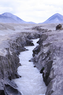
When Novarupa exploded it left 3 cubic miles of tephra in the Ukak valley spread out over 40 square miles with an average depth of 100 feet, and range of 40-700 feet.  This is one of my favorite shots showing how glacier streams have carved their way through the tephra back to the Naknek Lake.
I found this price of drift wood on the Naknek beach at Brooks Camp and it became my hiking staff.  It was quite sturdy and had a nice soft bow.  Looking that the top (the roots) one of the guests mused that it looked like a weapon from Lord of the Rings.  Those roots spreading out made a for a nice rest, a spot to hold a camera bag or a water bottle.  It also helped me fish my jacket out of the river when I dropped it once.  It was an excellent hiking staff.


Well, this concludes my posts about my visit to Katmai National Park and Preserve where I visited Brooks Camp to examine potential historic buildings before hiking about 40 miles through the Valley of Ten Thousand Smokes over three days.  If you ever make a trip to Alaska, I recommend visiting even if you only take the bus tour to see the Windy Creek Overlook without hiking the valley.

Brooks Camp II

Welcome to the second of my three posts on my Katmai trip.  After completing my work on Wednesday and Thursday, I took a long weekend and headed for the Valley of Ten Thousand Smokes (http://www.nps.gov/katm/planyourvisit/loader.cfm?csModule=security/getfile&PageID=305031).  On June 6, 1912 a volcano on the Alaska Peninsula erupted.  A total of four eruptions displaced more than 7 cubic miles of earthen matter into the air and the nearby valley.  Once known as the Ukak valley, it was soon covered in tephra (volcanic matter).  Waters trapped underneath were heated into steam, which broke through the tephra.  Consequently, Robert Griggs of the USGS called it the Valley of Ten Thousand Smokes.  

 This is a view of the valley from the vicinity of the trail head. I took a bus 23 miles from Brooks Camp to the trail head on Friday morning.  The other riders were taking the bus out to the visitor center where they would have lunch and then join a ranger for a short 2 hour hike.  I disembarked the bus at 11 a.m. and headed out into the volcanic wilderness.
 As I mentioned earlier the volcano exploded four times.  One of those explosions actually emptied andesite lava from underneath an adjacent volcano combing different types of rock.  Disclaimer: I am not a geologist, but I believe this is a heterogeneous composition of ryolite and andesite which would have come from the third explosion.
My most exciting find!  This is a piece of ryolite.  The pumice from the first explosion was described as a snow white ryolite pumice.  This is the only piece I saw during my 40 miles of trekking through the valley. 
My hike on Friday consisted of a 14 mile walk out to Baked Mountain.  I crossed this river (at a different) spot about an hour after I began.  All of the reddish colored soil is volcanic deposit.  99 years later, the Lethe River has cut its way across the valley again.  The water is glacier fed and thus very cold and it is also quite swift.
 The mineralization of the rocks and soil around me were amazing.  Unfortunately, I do not have the space or time to share all of these pictures.  I do not know for certain, but I think this may be a location of one of the ten thousand smokes, a place where steam broke through the volcanic matter to escape from the surface of the valley.
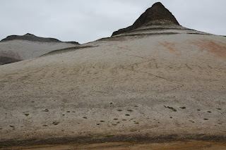
This is baked mountain with an elevation a little over 3800 feet, but look closely.  The purplish material toward your viewing right is indeed rock, but that tan-ish stuff is finely ground tephra.  Have you ever walked on the sand on the beach?  Now, consider what it would be like trying to hike 700 feet vertical on that terrain.  However, before I could even consider that, I had to deal with the Lethe River.
 The Lethe River is not particularly large, but it is swift.  The width along here is about 10-12 feet and the depth is only about 4 feet.  However, when I placed a sturdy hiking staff into the current to test the depth, it was so swift that I could barely hold the staff vertical with single hand.  I walked up and down the south (right) side of the river for over half an hour trying to find a spot to cross.  I found a few short sports where I could climb down one side and climb back up the other, but inevitably, they current was too fast to attempt a crossing.  Some fools might be tempted to vault the river with a quick jump.  Even for those who could jump ten feet, could it be done with 40 pounds of gear?  If you slip on a wet rock on the landing you would been in the water.  The danger of the Lethe River comes not from its depth but the combination of the swift and cold current; hikers have died crossing this river, but not I.
Unable to find a crossing (above) I kept moving. Nearing 5 p.m. I began to consider camping for the night, because I estimated that the cabins on Baked Mountain would be at least two hours from the river crossing.  Suddenly, I discovered this large pool with gentle ripples.  I crossed the Lethe River at the widest spot with a depth of about 12 inches and a very passive current.
 In the background you will see Mt. Griggs under clouds.  The foreground is the slopes of Baked Mountain.  My body sank into the tephra with each and every step up.  I was stepping up as quickly as I would sprint on solid ground.  With an additional 40 pounds on my back, this challenge was enough to force me to rest every 60-70 steps.  It took me over an hour climb 700 feet vertically.  I think I covered 1/4 - 1/2 mile horizontally in that time.
Paradise!  At 7:12 p.m., I crested the lower spine of Baked Mountain and found the huts.  I probably could have walked around the mountain with greater ease, but in hindsight climbing over it was a great accomplishment.  These huts were created by the University of Oregon research team in the 1960s when they conducted scientific research in the valley.  They offered great protection from the wind and a flat plywood bed never felt so good!

Brooks Camp I

Welcome to the first of three posts on my trip to Katmai National Park and Preserve (http://www.nps.gov/katm/index.htm)

I left Anchorage on Tuesday afternoon and flew to King Salmon.  Then on Wednesday morning, I took this float plane from King Salmon out to Brooks Camp.  This was my first flight in a float plane.  It is very load but did not feel particularly different that other flights.
I had a window seat on the right side of the plane and this was my first view of Brooks Camp early on Wednesday morning.  The building on the left  is the Barabara Exhibit Shelter which houses a reconstruction of a semi-subterranean native house. This area is noted for its archaeological wealth.


Here we have the main attraction, the bears!  These wild creatures are fishing along the Brooks River in an area called the Oxbow.  Bears arrive in late July and early August to fish during the salmon run as the salmon move upstream to spawn. Then the bears return in early September after the salmon have spawned and the carcasses begin to float back down stream.  At other non-hibernation times the bears search for roots and berries, usually close to the east coast of the Alaska peninsula.

Although Katmai became a national monument in 1918 it was closed by the park service for thirty years and not opened until a concessioner built a lodge and several cabins.  This is actually the second lodge built in 1961.  However, it and several other buildings have reached 50 years in age.  I went to Brooks Camp to evaluate the buildings through photographs and ask questions about alterations.  In some cases I also took measurements.  Like everyone else, I used my off time to enjoy the Alaska wilderness.


After work one evening, I hiked up to Dumpling Mountain and took some photos.  This view is looking southeast through the glacier moraine into the Iliuk Arm of Naknek Lake.  Mount La Gorce is on the left, Mt. Katolinat on the right and the volcanoes in the background.


This is another view of Brooks Camp from one of the Dumpling Mountain overlooks.  None of the camp buildings are visible, but the water closest to the bottom edge of the picture is the oxbow.  I have an earlier picture of bears fishing in the oxbow.
After my hike, I headed back toward the lodge to sort out the various papers I had been using to collect building information.  On my way I saw a mother fishing for her cubs along the Naknek beach.
About a half an hour later, that same sow brought her cubs right into the middle of camp.  I just happened to be sitting in the lodge right next to the window where the bears came to graze on the grass.  In an instant everyone in the lodge was pressed up against the window snapping pictures.  The bears stayed for about 20 minutes.


One of my favorites.   In the evening, I attended the ranger talks before returning to my tent in the campground.  The campground is about 1/4 mile from the lodge buildings.  At one point I decided to step out onto the Naknek beach and was treated to a beautiful evening panorama.


Tuesday, October 4, 2011

My Workplace

 This is the Alaska Regional Support Office of the National Park Service located on 5th Avenue in Anchorage, AK.  It is a fairly new building, at least for the NPS, which has excellent windows.  I have a cubicle located on the fourth floor facing 5th Avenue.  My window appears to be just below the flood light on the lamppost. 
 This is my cubicle.  I enjoy the fact that I have two computer screens and have the ability to move windows back and forth.  This is helpful when I write portions of papers in multiple pieces while checking historic preservation practices and previous successful nominations. For my fellow NPS employees, if you look closely at the screen on left you will see the NPS internet warning software warning me about the insecurity of the NPS e-mail platform and advising me against use of the website.
 My office a few weeks late.
 Job perk!  I have the ability to check out archival items and take them back to my desk. Okay, this might not be earth shattering to some, but if you have ever been the national archives where half of the staff eyeballs you like a criminal and the other half ignores you as if you are looking at something as valuable as confetti, this is a nice upgrade!
 This is my view looking North at the parking garage.  Its not particularly picturesque, but it does allow for a great deal of natural light and if tedium seems to persist there is the opportunity for a brief respite with people watching.  

Here is my view looking to the northeast.  Unfortunately, I could not find any camera angle to doe this view justice.  I have a great view of the Chugach Mountains just outside Anchorage.  This was taken in July, but now they are all snow-capped!


Here is my view to the northwest.  The parking garage connects to the 5th Avenue Mall.  I find it odd that I frequent a mall on a weekly basis, but it is helpful having my bank, the post-office and Subway just across the street.  In the background you can see a pair of towers.  The one on the right is the Hilton Hotel.  I live just across the street from the Hilton in a basement apartment.  My morning commute, five blocks.


At this point you may be wondering what I am doing, other than taking an extended vacation.  I work as a historian for the National Register Initiative which nominates NPS properties to the National Register of Historic Places (http://www.nps.gov/nr/).   The National Trust for Historic Preservation as a great explanation of the NR (http://www.preservationnation.org/magazine/2011/may-june/what-is-the-national-register.html), but I can also give you the one sentence version.  The National Register is a list of important historic places and buildings throughout the United States that records the historic, landscape and architectural details of that place, both historical and current. 

Specifically, my job is to look at properties and buildings held by NPS units in Alaska and prepare nominations when appropriate.  Generally, properties have to be 50 years or older.  Thus far I have looked at a fishing camp, and hot springs traditionally used by Alaska natives and the creation of a visitor center as part of Mission 66 at a third park.  Since, I don't want to add too much detail about the job, I will leave my written comments as is, but if you wish to ask questions, please do so.

Next: I will blog about my trip to Katmai National Park and Preserve and Hiking through the Valley of Ten Thousand Smokes.  This will be a 3 or 4 post series.