Welcome to the third, an final, installment on my visit to Katmai National Park.
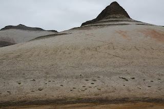
 This is a small valley between Baked Mountain and Broken Mountain, I think you can connect the volcanic eruption to the names of each mountain. I got up Saturday and began my hike about mid-morning. My goal was to see as much as possible, but especially to climb into the volcano that caused the great eruptions.
Here I am at the top of Baked Mountain, 3695 ft above sea level. Note the geodetic survey marker next to my left shoulder and of course my Penn State t-shirt! In the background is Mt. Mageik with its glaciers. It took me about an hour to climb 1000 ft up Baked Mountain, most of which was fractured slate like rock. It reminded me of the rock at Willoughby run at Gettysburg. I had lunch at the top of Baked mountain and then continued my hiking.
This was my first view of Novarupta, the volcano that cause all of this. For over 40 years, Novarupta was overlooked as a secondary eruption because it does not resemble a mountain and was not previously identified as an active volcano. However, it did erupt at least 3 times, maybe 4. Today, it is inactive.
This a view of my descent from Baked Mountain. The apogee is the background on the left and one of the three finger peaks is more prominent. If you look closely, you will see the zig-zag pattern I used to ski down the mountain about 1500 below to the valley floor. I say skiing because the sand provided a surface with minimal friction and I descended very quickly.
Here is another view of the mineral rich valley floor. Mt. Mageik is in the background behind Mt. Cerebus (both on the left) and Baked Mountain is on the right. Mount Martin is the center background. The valley floor was very soft and frequently had a crust-like surface that reminded me of dried mud.
Walking through a dry river bed, I discovered this feature. Although the glaciers had melted earlier in the summer (or sometime further in the past), this item remained behind. It is a huge chuck of ice covered in tephra. I am not sure how well the picture will come through, but it had a very light pink coloration in person. I brushed off the dirt and excavated ice into 3 gallon-zip lock bags. After it melted, I treated the water and used that as my drinking water for Saturday evening.
Late in the afternoon, I climbed up the remnants of Novarupta. The loose rock was difficult to somewhat challenging to navigate but I have now summitted a volcano! If you can increase the size of the picture, look for a small blue dot in the center, that is my pack.
There is life in the valley! During my Friday hike out, I saw a plane fly overhead and then on late Saturday as I returned to the huts, I saw a few birds. Other than that, it was just me hiking in the middle of the wilderness. Peace and quiet!
I rose early Sunday morning and descended 700 feet down from the Baked Mountain spine. What took an hour going up, took only 7 minutes going down. Unfortunately, the sunrise was behind me, but from time to time, I turned around for photography. This is Mount Griggs during sunrise.
I reached the Lethe River near 8 a.m. on Sunday morning. I took my boots off and slung them around my neck. Then I rolled my jeans above my knees and crossed the river in double-socks. It was frigid! Seriously, I think the water temp was at 32.0001 Fahrenheit. As soon as I reached this bank, I took off my socks, dried my fit with a shirt and put on dry socks to continue my hike back to the trail head.
When Novarupa exploded it left 3 cubic miles of tephra in the Ukak valley spread out over 40 square miles with an average depth of 100 feet, and range of 40-700 feet. This is one of my favorite shots showing how glacier streams have carved their way through the tephra back to the Naknek Lake.
I found this price of drift wood on the Naknek beach at Brooks Camp and it became my hiking staff. It was quite sturdy and had a nice soft bow. Looking that the top (the roots) one of the guests mused that it looked like a weapon from Lord of the Rings. Those roots spreading out made a for a nice rest, a spot to hold a camera bag or a water bottle. It also helped me fish my jacket out of the river when I dropped it once. It was an excellent hiking staff.
Well, this concludes my posts about my visit to Katmai National Park and Preserve where I visited Brooks Camp to examine potential historic buildings before hiking about 40 miles through the Valley of Ten Thousand Smokes over three days. If you ever make a trip to Alaska, I recommend visiting even if you only take the bus tour to see the Windy Creek Overlook without hiking the valley.


No comments:
Post a Comment